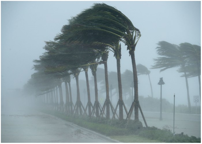
Tropical meteorologists often rely on subtle cloud formations seen in satellite images as the first hints of something more ominous brewing in the atmosphere. These early signs, such as wispy cirrus clouds radiating outward, curved banding low-level clouds, and drops in atmospheric pressure, are crucial in predicting the onset of what might develop into a catastrophic hurricane. Recognizing these early indicators can provide the necessary warnings to potentially save lives and protect property.
Understanding the Birth of a Hurricane
Hurricanes typically originate from atmospheric tropical waves, areas of low pressure associated with clusters of thunderstorms. As these waves move westward across tropical oceans, some have the potential to develop into hurricanes. However, the formation of these powerful storms hinges on several critical conditions.
The Role of Distance from the Equator
One of the key factors in hurricane formation is the distance from the equator. Tropical cyclones generally form at least 5 degrees away from the equator due to the Coriolis force, which is essential for initiating the swirling motion of a cyclone. This force, caused by Earth’s rotation, is weaker near the equator, making it less likely for hurricanes to form close to this region.
Importance of Warm Sea Surface Temperatures
Warm sea surface temperatures play a vital role in fueling hurricanes. The ocean’s surface must be at least 26.5 degrees Celsius (about 80 Fahrenheit) to provide the necessary energy for a hurricane to form. This warm water supplies the storm with heat and moisture, driving its development and intensity.
Atmospheric Instability and Moisture
Another critical factor is atmospheric instability and moisture. An unstable atmosphere, where warm surface air rises and remains warmer than the surrounding air, is crucial for hurricane formation. This rising air helps form thunderstorms, which are the building blocks of a hurricane. Additionally, there must be ample moisture in the atmosphere to prevent clouds from evaporating and to maintain the upward motions within the thunderstorms.
The Impact of Vertical Wind Shear
Vertical wind shear, which refers to changes in wind direction or speed at different elevations, can disrupt a developing hurricane. Strong wind shear can tear apart a storm’s formation, making it difficult for the hurricane to maintain its vortex alignment. Therefore, low vertical wind shear is essential for a hurricane to develop and grow.
Early Detection and Forecasting Challenges
Identifying the early stages of a hurricane is challenging, especially over the open ocean, where there are few surface stations or weather balloons to provide detailed atmospheric information. Once a storm begins to form, NOAA’s hurricane hunter airplanes often fly through it, gathering data by dropping sensors. However, this isn’t feasible for every potential storm, especially when it’s far from the coast.
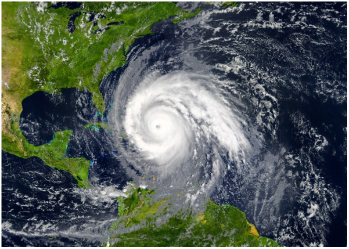
Satellite Imagery: A Crucial Tool
One of the primary tools meteorologists use to forecast early hurricane formation is satellite imagery. Satellites like NOAA’s GOES provide real-time data on cloud patterns, sea surface temperatures, and other atmospheric conditions. These satellites capture images at multiple wavelengths, allowing forecasters to analyze different aspects of the storm, such as cloud formation, precipitation, and lightning activity.
However, satellite observations alone are not always enough to determine which tropical waves will develop into hurricanes. To improve the accuracy of hurricane forecasts, researchers are working on enhancing forecasting models by incorporating real-time satellite data, including humidity levels and cloud patterns, into computer models.
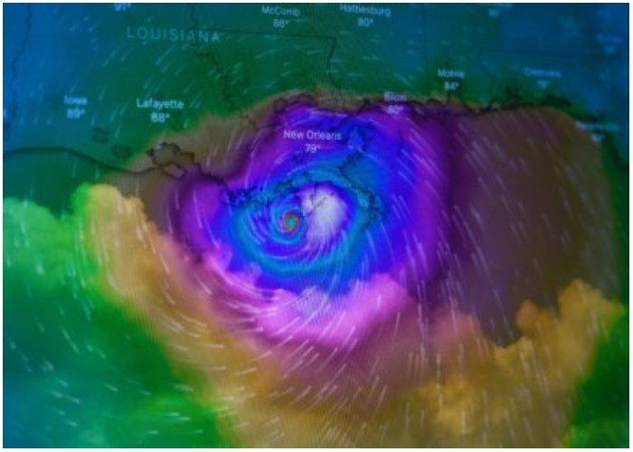
The Process of Data Assimilation
The process of incorporating real-time satellite data into forecast models is known as data assimilation. This technique allows for a more precise and consistent depiction of atmospheric conditions. As a result, forecasters can better predict the formation and progression of hurricanes.
Collaborative Efforts for Better Forecasting
Our research group at Penn State is currently collaborating with NOAA to refine these techniques and integrate them into broader use. The goal is to provide better hurricane forecasting and earlier warnings, giving the public more time to prepare for potentially devastating storms. As meteorologists continue to develop and refine forecasting methods, the aim is to ensure that everyone has the information they need to stay safe during hurricane season.
The Importance of Early Warnings
Accurate early storm forecasting is crucial, especially as people in North America and the Caribbean prepare for what is predicted to be an especially intense hurricane season in 2024. Early warnings give individuals and communities the time they need to take necessary precautions and protect themselves from the potential impact of a hurricane.